Decipher the Power of Geospatial Artificial Intelligence
Decipher the Power of Geospatial Artificial Intelligence
In the realm of data analysis, navigating gargantuan datasets comprising millions of instances presents a formidable challenge, often leaving the human mind perplexed in its quest for meaningful insights. However, a transformative approach emerges when a positional perspective is introduced into the data landscape. This nuanced perspective has the power to illuminate intricate patterns and nascent trends, thereby amplifying the value and credibility of the information at hand.
Enter the realm of geospatial artificial intelligence (AI), a powerhouse that transcends the limitations of traditional visual analysis conducted by the human brain. By integrating advanced AI and machine learning (ML) engines, equipped with ever-evolving statistical crunching mechanisms, geospatial AI unveils a comprehensive set of conclusive evidence and actionable insights. This fusion of location intelligence and AI stands as a testament to the extraordinary capabilities that arise when technology meets spatial awareness.
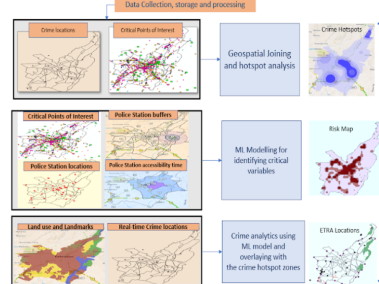
An outstanding embodiment of this technological synergy can be witnessed in Deepspatial, a pioneering presence within the industry. The advanced location analytics offered by Deepspatial, combined with the computational power of AI, surpasses traditional limitations. This synergy proves particularly impactful in crucial sectors like security and law enforcement. Imagine a scenario where vast volumes of data are seamlessly transformed into a strategic tool for identifying patterns indicative of crime-prone spots and hotspot zones. Through the meticulous analysis of demographic information, points of interest (PoIs), and real-time crime alerts, a robust system is devised, significantly expediting the reporting process.
The amalgamation of geospatial artificial intelligence, with its ability to navigate complex datasets, and the precision of location analytics not only revolutionizes decision-making processes but also propels us into an era where the synergy of human insight and machine intelligence becomes a potent force. Figure below clearly shows how the combination of geospatial artificial intelligence transforms data, visually demonstrating its ability to navigate complex information for improved decision-making.
This blog delves into the capabilities of Geospatial Artificial Intelligence (GeoAI) and its role in facilitating informed decision-making. GeoAI is a multidisciplinary domain encompassing spatial science, statistics, computer science, and engineering. It bridges theoretical, epistemological, and scientific aspects to unite AI and geography. In our swiftly changing world, Geospatial Artificial Intelligence emerges as a promising tool for analyzing vast datasets, generating information of immense depth and breadth.
In the current landscape, where both corporate and government leaders seek crucial insights to fortify their operations and strategic decision-making, geospatial technologies offer a reliable solution. By harnessing the power of GeoAI, they can effectively address challenges and gain valuable information. This prompts the question: What makes GeoAI so potent, and how does it contribute to making better decisions in our lives?
GeoAI Demystified: Navigating the Future of Spatial Intelligence
Geospatial Artificial Intelligence (GeoAI) is a transformative discipline that leverages artificial intelligence technology to analyze geospatial data, mirroring human perception, spatial reasoning, and the exploration of geographical phenomena. This innovative field seeks to propel our understanding and address complex human-environmental systems.
In the contemporary landscape, numerous organizations and governments are undergoing digital transformations, harnessing the potential of geospatial technologies. This strategic shift is revealing data-driven insights crucial for informed decision-making in various sectors, including Healthcare, Environmental Monitoring, Law Enforcement, Emergency Management, Land Use Planning, Utilities and Infrastructure, Predictive Maintenance, Asset Management, Fraud Detection, Forest Mapping, Drug Discovery, and Disaster Response.
The disruptive influence of GeoAI extends to revolutionizing natural resource management and shaping responses to environmental challenges. A striking example lies in its ability to identify data patterns predicting the occurrence of events like wildfires, thereby enhancing disaster response and mitigation strategies. Additionally, GeoAI plays a pivotal role in optimizing irrigation and water usage by discerning patterns in data, contributing to effective water resource management.
As we navigate the intricacies of GeoAI, it becomes evident that this technology holds the promise of reshaping how we manage our environment, offering valuable insights and solutions to the complex challenges we face.

Potential Benefits of GeoAI
The immense advantages of GeoAI enable both public and private entities to enhance their comprehension of data, offering several benefits such as:
- Enhancing decision-making through the provision of precise and current information on specified locations.
- Gaining access to well-informed insights for strategic planning.
- Efficiently saving time and financial resources.
- Maintaining a competitive edge.
- Identifying potential risks and opportunities.
- Accurately predicting demand for products or services in specific locations.
- Crafting more focused marketing or awareness campaigns
Challenges in GeoAI Implementation
While GeoAI holds immense promise with numerous potential applications and advantages, it also confronts a spectrum of challenges that demand attention for its optimal realization. Some key hurdles include:
- Data Fragmentation: The widespread distribution of data across diverse platforms and silos poses a formidable challenge, complicating the collection and analysis processes.
- Data Quality Issues: The presence of noisy and incomplete data adds complexity, hindering the ability to derive accurate and reliable conclusions from the information.
- Bias in Data: The inherent bias in data introduces a significant obstacle, making it challenging to develop models that faithfully represent the intricacies of reality.
- Technical Deployment Challenges: Implementing GeoAI models can be demanding due to their reliance on specialized hardware and infrastructure, adding an additional layer of complexity to the deployment process.
However, despite these formidable challenges, the transformative potential of GeoAI is substantial. Leveraging its capabilities offers a unique opportunity to revolutionize our interaction with the world, providing a deeper understanding of our planet and facilitating improved decision-making. GeoAI has the potential to empower us to make informed choices about resource utilization, respond effectively to natural disasters, and safeguard our environment.
Deepspatial’s GeoAI: Illuminating the Future of Geospatial Intelligence and Business Evolution
In the dynamic landscape of the geospatial industry, the fusion of Artificial Intelligence (AI), Big Data, Internet of Things (IoT), Cloud Computing, Augmented Reality/Virtual Reality (AR/VR), and Automation has paved the way for transformative advancements. GeoAI, as the driving force behind these innovations, holds the key to unlocking the vast potential inherent in geospatial data.
As organizations increasingly harness the power of GeoAI for diverse applications such as precision farming, disaster management, retail and logistics, navigation, and beyond, it becomes evident that GeoAI is not just a technological evolution but a revolutionary paradigm shift. The ability to analyze the location of earth objects and derive actionable intelligence has become integral to strategic decision-making.
In this transformative landscape, DeepSpatial’s GeoAI emerges as a beacon of progress. Through advanced spatial data analysis, map generation, and simulations, DeepSpatial empowers businesses and government entities to predict future outcomes with enhanced efficiency, accuracy, and timeliness. The functional insights provided by DeepSpatial’s GeoAI are invaluable, aiding decision-makers across various scenarios.
The impact of GeoAI extends across sectors, enabling businesses to optimize operations in precision, from supply chain networks and market planning to product selection, asset maintenance, customer service, and strategic site selection. DeepSpatial’s GeoAI doesn’t just analyze demographics; it uncovers patterns and trends in customer behaviour, providing companies with the tools to allocate resources effectively, create personalized marketing campaigns, and make informed decisions that elevate their businesses to new heights.
In conclusion, GeoAI is not just a technological tool; it’s a transformative force that is reshaping the future of industries. DeepSpatial’s GeoAI stands at the forefront of this revolution, offering a gateway to unprecedented insights and opportunities, revolutionizing the old ways of doing business, and ensuring that businesses and government entities not only survive but thrive in the era of intelligent geospatial solutions.

Geospatial industry is driven by Artificial Intelligence (AI), Big Data, the Internet of Things (IoT), Cloud Computing, Augmented Reality/ Virtual Reality (AR/ VR), and Automation. The technology solutions are leveraging AI to unlock the potential of geospatial data. Now, with increasing availability, geospatial data is being used broadly by organizations exploring the ability to analyze the location of earth objects to derive actionable intelligence. GeoAI applications can aid end-to-end solutions in precision farming, disaster management, retail & logistics, navigation, and several other areas.
GeoAI will revolutionize the world and will change the old ways of doing business and it will be impossible for any business sector or government entity to survive and grow without it.